
Open-Source ITS & Connected Vehicle Architecture
The Need for Open-Source ITS Architecture to Accelerate Connected Vehicle Operations
Emerging technologies are making available new datasets that can help revolutionize traffic management methods if Infrastructure Owner Operators (IOOs) are able to access and leverage the data, applying the actionable information within an Intelligent Transportation System (ITS). However, the advancement of new roadway technologies has outpaced ITS’ ability to standardize the data exchange and management.
A consequence of the growing standards gap is increasing the proliferation of proprietary data and control systems. Collaborative efforts are underway to establish a referential open-source platform as a proposed addition to our National ITS Architecture. 1 This paper examines the implementation of an open source ITS architecture for a Connected Vehicle (CV) environment, providing a more agile framework that overcomes systemic challenges within the National ITS Architecture to help accelerate the deployment and extensibility of new ITS and CV solutions, including new Artificial Intelligence (AI)-driven applications and strategies.
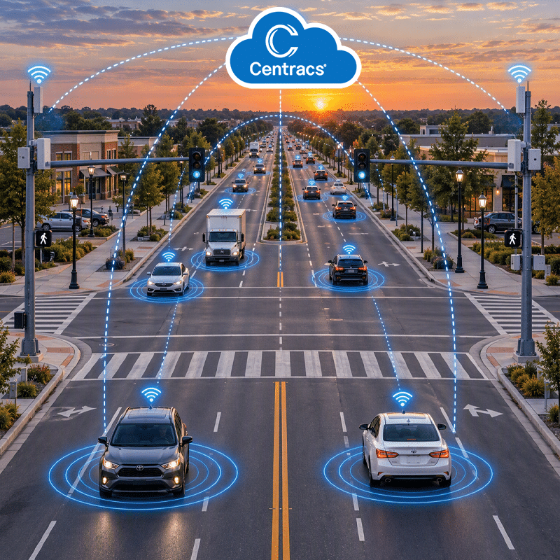
The ITS Project Overview
The Innovate Mound project involves the reconstruction of a nine-mile stretch of Mound Road between I-696 and M-59 located in Macomb County, Michigan. The goal is to transform the roadway into a smart corridor that includes the deployment of emerging mobility, AI-driven, and automated technologies that will enhance safety, optimize efficiencies, and help future-proof the multimodal corridor.
Another objective is to make this corridor a showcase for the future of transportation safety and mobility by implementing diverse data-driven traffic management strategies, CV technologies, advanced software, predictive/forecasting applications, and scientific techniques—leveraging public and private partnerships to deliver a system concept that can be extended across the county, region, and to neighboring states.
In addition, the design and implementation of an open-source framework seeks to overcome systemic technology and data management standards challenges within the National ITS Architecture’s current state of practices and to provide an innovative solution that is extensible and that can be deployed on a national scale.
Public Partners & Technical Oversight Committee
The Innovate Mound public partners include Macomb County, Macomb County Department of Roads (MCDR), the City of Sterling Heights, the City of Warren, Federal Highway Administration (FHWA), Michigan Department of Transportation (MDOT), and Southeast Michigan Council of Governments (SEMCOG), who provide overall administration, coordination, project assistance, and act as a Technical Oversight Committee (TOC).
The National ITS Architecture: The Risk of Proprietary Solutions
Background
Generally, ITS procurements for software systems can place operational requirements at several levels of increasing solution specificity, as described below:
- Functional: Requirements placed on software end functionality, without constraint upon the software design.
- Modular: Requirements placed on modularity and interconnectedness of software components via Industry Standardized Interfaces, e.g., National Transportation Communications for ITS Protocol (NTCIP). This level is concerned with the modularity of the end system but does not offer much to constrain the internal design of each module.
- Architectural: Requirements placed on software architecture, source code, and toolchains for the greatest specificity of solution.
Early ITS software procurements focused on end-user functionality. As a result, during the personal computer revolution of the 1980s and 1990s, the ITS industry evolved toward deployment of “black box” or proprietary solutions that did not offer extensibility or cross-vendor integration. While those deployments enabled an immediate ITS capability for agencies, they were later found to constrain these agencies with proprietary data interfaces that did not allow for interoperability with new technologies and systems that were later deployed and implemented. Fortunately, in the late 1990s, work through the NTCIP standardization released our National ITS Architecture from this proprietary binding.
Current State
Public agencies, private industry, and the transportation research community have been collaborating for more than 30 years toward a common goal of the design and deployment of a standardized National ITS Architecture using NTCIP as the means of ensuring cross-vendor modularity of subsystems. The guiding objectives of this design were focused on device interoperability via standardization of data interfaces between roadway users, management centers, vehicles, and infrastructure field devices (Figure 1).
Recent deployments of CV-based ITS systems have revealed a significant gap between National ITS Architecture version 5 and the forthcoming inclusion of the broader set of use cases and applications of many transformational technologies promised by the interconnectedness of new ITS devices and systems. There has been an emergence of new field devices, crowd-sourced datasets, cloud-hosted analytics, and other technologies that can serve our shared goals to improve roadway safety and mobility, but only if these technologies can be given access to ITS systems and their data.
Figure 1: National ITS Architecture v.5
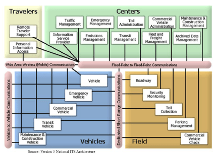
Newer deployments of ITS/CV solutions have been encumbered by these NTCIP interfaces and cannot implement many emergent capabilities to improve safety and mobility, due largely to data exchange incompatibilities as a result of data management and communications constraints of legacy standards. Unfortunately, change for these standards cannot keep pace with emergent technologies, leaving a significant ITS standards gap. What can be done if industry standards are critically important to stave off another era of proprietary systems?
Open-Source Architecture: Mitigating the Risk of Returning to Proprietary Solutions
Our industry must remember the lessons learned in the 1990s as we begin to see the emergence of new data-driven ITS capabilities and AI-powered applications. While we have not yet adequately developed the underlying standards and policies to apply these technologies consistent to our National ITS Architecture, an open-source cloud-based architecture is a viable answer. An open-source approach to an ITS platform offers the same collaborative openness as standards, but can move faster, and be more responsive to change.
Currently, there is not a mandated open-source cloud architecture within the National ITS architecture, however a reference architecture is currently being fostered by USDOT’s Joint Program Office (JPO) through several open-source programs. A community of practice has been established to develop and study a new reference architecture based upon developing a set of open-source, containerized microservices platforms.
Design Approach to Innovate Mound Project
Following an open-source platform approach, an ITS solution was developed that verifies intent and refines the requirements as required to build upon an open framework and open-source architecture that is composed of several USDOT and FHWA projects. This is critical for any highly integrated ITS system and will see the output of the Innovate Mound program uniquely contributing to the emergent FHWA-led GitHub repositories that are currently expanding to replace the prior “modular” National ITS Architecture.
The core solution will be open-sourced, offering these advanced solutions on a national scale. Moreover, Macomb County and MDOT will be able to leverage services from other ITS data exchanges being developed within these open-source programs (e.g., CARMA Streets) and continue to expand the breadth, capabilities, and inclusiveness of this system.
This ITS solution seeks to support CV applications that vehicle Original Equipment Manufacturers (OEMs) can easily apply within their vehicles’ operating systems. These data elements encompass very complicated datasets that cannot be simply characterized by a brief description or reference to existing standards. There are underlying standards, data transformations, data integrity methods, infrastructural requirements, accuracy expectations and many other factors that must be considered before utilizing this data in any in-vehicle safety system.
The intent is to develop a set of open source microservices that provide absolute clarity of these data transformation methods, as well as establish an extensible solution that the transportation industry can update as new edge devices, data transformation methods, and other technologies arise. Following this rationale, the platform adheres to the following architecture design goals (Table 1):
Table 1: ITS Architecture Design Goals
- Generation of a Digital Replica of the roadway infrastructure
- Utilization of open-source toolchains and source code
- Creation of de-facto standards within ITS
- Adoption of the latest technologies
- Modular and layered software architecture
- Utilization of microservices
- Microservice-level testability
The ITS Data Exchange Overview
The software framework, as well as several CV applications that demonstrate the capabilities of this collective system, has been designed to support the following Data Exchange and software application elements for this project at this time (Table 2):
Table 2: ITS Data Exchange Applications
I2VNC
Traveler Information and Notification Center
Traveler Information and Notification Center
The traveler information and notification center (I2VNC) serves as the core data broker, event handler, and information dissemination software that collects, processes, and leverages a sophisticated rules engine to prioritize, coordinate, and optimize critical events, alerts, notifications, and ongoing content updates from CV apps (inclement weather, speed restrictions, incidents, road closures, and pavement conditions). The service assembles important travel information and formulates an information delivery experience that is harmonized for both the traffic operator and drivers, while enabling MCDR to utilize RSUs, OBU, and C-V2X infrastructure to communicate with vehicles and other connected travelers.
WWD
Wrong Way Driving
Wrong Way Driving
Wrong Way Vehicle Detection and Warning (WWD) system is being implemented as a light-weight software application that uses data from ITS detectors, CCTV video surveillance, vehicle onboard equipment, and CV roadside equipment to detect wrong-way drivers and immediately warn drivers, nearby CV equipped vehicles, traffic operators, and incident management personnel.
WRS
Atmospheric Sensor Data Integration
Atmospheric Sensor Data Integration
Weather Response Service (WRS) CV application is being developed as a software algorithm designed to evaluate and respond to inclement weather data to determine optimized travel speeds for the speed harmonization SPHM CV app, supporting the queue detection warning QDW app, and determining weather-based safety hazards requiring I2V notifications based on current road weather conditions.
PQD
Pavement Quality Detection
Pavement Quality Detection
The Pavement Quality Detection (PQD) CV application is envisioned as a software algorithm designed to leverage connected vehicle sources, including OBU, RSU, and other CV applications to evaluate, respond and alert on pavement conditions having an impact on traffic safety and mobility. To accomplish this, the PQD app uses pavement sensor data from the provided vendor software to detect and notify the queue detection warning (QDW), speed harmonization (SPHM), signal phase and timing (SPaT) and triggers the I2VNC to alert drivers of PQD safety hazards.
QDW
Queue Detection and Warning
Queue Detection and Warning
The Queue Detection and Warning (QDW) CV application utilizes a software algorithm designed to leverage connected vehicle sources, including OBU, RSU, and other CAV applications to evaluate queue status at designated locations and alert on conditions having an impact on traffic safety and mobility in order to generate appropriate queue response strategies. To accomplish this, the QDW app collects OBU BSM I, BSM II, vehicle event data, and RSU aggregated data to report queue status to MCDR for further processing. The QDW also triggers the I2VNC to broadcast queue warnings to equipped vehicles.
SPHM
Speed Harmonization
Speed Harmonization
Speed Harmonization (SPHM) system fuses data from ITS field devices, atmospheric sensors, RSU and OBU CV data, and other relevant traffic data to recommend travel speeds for successive upstream roadway segments in small increments to achieve common speeds based on the prevailing conditions detected.
SPaT
Signal Phase and Timing
Signal Phase and Timing
Signal Phase and Timing (SPaT) system serves as an interface to broadcast Traffic Signal System (TSS) Controller data to OBU-equipped vehicles.
The software architecture is designed to provide the operational Data Exchange between each of the applications noted in Table 2, as well as any edge computing and cloud processing. A high-level working design documentation has been drafted as part of the project to provide Macomb County an opportunity to review and influence the intended design, as well as forming the framework for existing and new project partners in the design, development, integration, deployment, training, and testing of this ITS software system.
Open-Source Containerized Micro Service-Based ITS Architecture
Taking into consideration the applications and data exchange requirements, the following architecture is being implemented. It follows the FHWA architecture guidance offered through the FHWA open-source GitHub repositories. Two specific open-source platforms are deployed:
- V2X Hub3 (Figure 2)
- JPO-ODE4 (Figure 3)
Figure 2: V2X Hub Operational Diagram Example
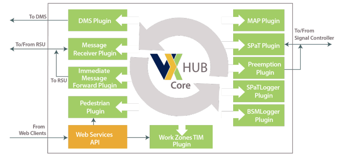
Figure 3: JPO-ODE TMC Environment

The ITS Data Exchange Architecture
Containerized Microservice
To develop and deploy a software framework based upon the USDOT open-source data management for the project, the following ITS data exchange architecture was designed and implemented to address the containerized microservice capabilities required (Figure 4):
Figure 4: The ITS Data Exchange Framework
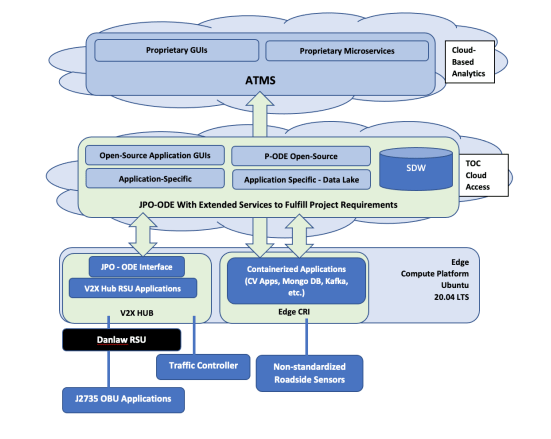
This containerized microservice-based framework offers edge (V2X Hub), and cloud computing platforms (JPO-ODE), and Situational Data Warehouse where the CV applications can reside. This architecture also enables a mixing of platforms, where some applications may have elements best hosted at the edge level and other elements best hosted in the cloud. The architecture is designed in support the following services:
1
Application / Container Runtime Platforms
Application / Container Runtime Platforms
2
Data Exchanges (for both Standardized and Proprietary Datasets)
Data Exchanges (for both Standardized and Proprietary Datasets)
3
Data Storage (via Structured Databases and filesystem/Data Lake storage)
Data Storage (via Structured Databases and filesystem/Data Lake storage)
4
Security / Data Access / Management
Security / Data Access / Management
Summary and Key Takeaways
The open-source containerized microservice-based architecture developed for the Innovate Mound project is designed to provide a framework that overcomes the current systemic challenges of the National ITS Architecture to help accelerate the deployment and extensibility of new ITS and CV solutions while avoiding the historical pitfalls of proprietary-based solutions of the previous ITS eras. It was also designed to leverage standardized interfaces wherever possible. The system architecture is highly modular, leveraging the current NTCIP and SAE interfaces supported within the National ITS Architecture. It separates functional elements via center-to-center and NTCIP 1211 dialogues. This provides built-in expandability and ITS data exchange agility to help ensure interoperability with any vendor’s traffic controllers, ATMS, and transit management system, making it a robust solution for managing multijurisdictional operations. With the underlying goal to mitigate the risks of proprietary system binding, the open-source architecture and framework is also designed to easily integrate and interface with future traffic control capabilities, including the anticipated datasets that will be produced from situational awareness, cooperative perception solutions, and AI-driven applications and strategies that will incorporate next-generation trajectory-aware, object classification, and tracking-based sensing data.
The architecture’s ITS data exchange framework also applies NTCIP and SAE standard dialogues, including extensions developed to support other emergent Smart City applications and environments. The project will extend these dialogues with current and future project IOO stakeholders to facilitate the capture and exchange of known and anticipated data flows and datasets. The ITS and CV open-source architecture described here is designed to enable Macomb County to set new ITS and community benefit benchmarks by maximizing the technical, institutional, and public-private partnership benefits for the Innovate Mound project, and which the framework can then be leveraged on a national scale.
Contact Us
We are here to help. Reach out to our team for assistance.
Click the button below to reach a team member for assistance or inquiries.
References
- The National ITS Reference Architecture, also known as the “Architecture Reference for Cooperative and Intelligent Transportation” or simply “ARC-IT” provides a common framework for planning, defining, and integrating intelligent transportation systems.
- The CARMA Program, developed by the Federal Highway Administration (FHWA), uses a multimodal approach to encourage collaborative research on the technology, open-source tools, and frameworks poised to improve transportation system mobility, safety, and efficiency. https://highways.dot.gov/research/operations/CARMA
- The V2X Hub: a communication, computation, and processing platform for V2X applications: https://github.com/usdot-fhwa-OPS/V2X-Hub
- JPO-ODE: a real-time virtual data router that ingests and processes operational data from various connected devices – including vehicles, infrastructure, and traffic management centers – and distributes it to other devices and subscribing transportation management applications: https://github.com/usdot-jpo-ode/jpo-ode